Sydney Catchment Authority:
Development Assessment Module

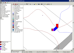
Plume model map

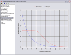
Plume model graph
project name
Sydney Catchment Authority - Development Assessment Module
the aim
The Sydney Catchment Authority (SCA) required a system to assess the potential risk of individual on-site effluent management systems. Spatial Intelligence was commissioned to develop a spatially enabled application to meet these requirements.
the solution
Martens & Associates developed algorithms especially for the SCA that model effluent plume. Spatial Intelligence incorporated those algorithms into an interface that allows for user input and reporting.
The Development Assessment Module (DAM) extracts the relevant GIS data for the location of the proposed on-site effluent management system. This includes slope, soil and climate data. The model then allows the user to enter additional configuration data and automates design calculations to predict the potential extent of an effluent plume. The predicted plume is then mapped to show the potential extent. Outputs include graphs, tables and a model report generated in Word.
The DAM is based on the following components:- Microsoft Windows
- SQL Server
- Microsoft Office
- ESRI ArcSDE
- ESRI MapObjects
Tags
more details
For more details please use our 'Contact us' page or email us at info@spatialintelligence.com.au